
Taylorville topographic map
Interactive map
Click on the map to display elevation.
About this map
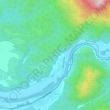
Name: Taylorville topographic map, elevation, terrain.
Location: Taylorville, Grey District, West Coast, New Zealand (-42.45698 171.29178 -42.41698 171.33178)
Average elevation: 410 ft
Minimum elevation: 10 ft
Maximum elevation: 1,877 ft
Other topographic maps
Click on a map to view its topography, its elevation and its terrain.
Greymouth
New Zealand > West Coast > Grey District
Greymouth, Grey District, West Coast, 7801, New Zealand
Average elevation: 131 ft
Atarau
New Zealand > West Coast > Grey District
Atarau, Grey District, West Coast, 7843, New Zealand
Average elevation: 194 ft
Lake Brunner
New Zealand > West Coast > Grey District > Moana
Lake Brunner, Moana, Grey District, West Coast, New Zealand
Average elevation: 551 ft
Ngahere
New Zealand > West Coast > Grey District > Ngahere
Ngahere, Grey District, West Coast, 7804, New Zealand
Average elevation: 161 ft
Ahaura River
New Zealand > West Coast > Grey District
Ahaura River, Grey District, West Coast, 7843, New Zealand
Average elevation: 1,266 ft