Geolocate

Spruce Pine topographic map

Click on the map to display elevation.

About this map

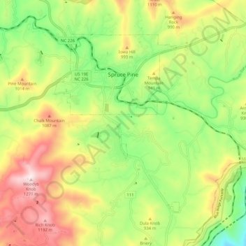
Name: Spruce Pine topographic map, elevation, terrain.

Location: Spruce Pine, Mitchell County, North Carolina, 28777, United States (35.86885 -82.09458 35.92821 -81.99352)

Average elevation: 2,877 ft

Minimum elevation: 1,883 ft

Maximum elevation: 4,137 ft

Mitchell County trails, hiking, mountain biking, running and outdoor activities

Other topographic maps

Click on a map to view its topography, its elevation and its terrain.

Normanville

United States > North Carolina > Mitchell County

Average elevation: 2,907 ft

Honeycutt

United States > North Carolina > Mitchell County

Average elevation: 2,799 ft

Minpro

United States > North Carolina > Mitchell County

Average elevation: 2,805 ft

Osborne Knob

United States > North Carolina > Mitchell County

Average elevation: 3,163 ft

Bailey

United States > North Carolina > Mitchell County

Average elevation: 2,493 ft

Grassy Creek

United States > North Carolina > Mitchell County

Average elevation: 2,756 ft

Grassy Creek

United States > North Carolina > Mitchell County

Average elevation: 2,756 ft

Carvers Gap

United States > North Carolina > Mitchell County

Average elevation: 5,203 ft

Gear up for your next adventure:

🥩Freeze-Dried Meals - Nutritious and lightweight food for remote expeditions
🔋Solar Power Banks - Keep your GPS and phone charged in remote wilderness areas
🛏️Cold Weather Sleeping Bag - Warm sleeping bag for cold conditions
🚪Portable Camp Chair - Foldable chair for comfort at camp
🧢Outdoor Hiking Hat - Sun protection hat for outdoor explorers

As an Amazon Associate, this site earns from qualifying purchases at no extra cost to you.