
Thank you for supporting this site ❤️
Make a donation
Make a donation
Gear up for your next adventure:
As an Amazon Associate, this site earns from qualifying purchases at no extra cost to you.
Kurugunda topographic map
Click on the map to display elevation.
Thank you for supporting this site ❤️
Make a donation
Make a donation
Gear up for your next adventure:
As an Amazon Associate, this site earns from qualifying purchases at no extra cost to you.
About this map
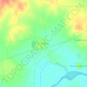
Name: Kurugunda topographic map, elevation, terrain.
Location: Kurugunda, Bailahongala taluku, Belagavi, Karnataka, India (15.71536 74.72627 15.75536 74.76627)
Average elevation: 2,129 ft
Minimum elevation: 2,054 ft
Maximum elevation: 2,244 ft
Thank you for supporting this site ❤️
Make a donation
Make a donation
Gear up for your next adventure:
As an Amazon Associate, this site earns from qualifying purchases at no extra cost to you.