
Make a donation
Gear up for your next adventure:
As an Amazon Associate, this site earns from qualifying purchases at no extra cost to you.
白石山 topographic map
Click on the map to display elevation.
Make a donation
Gear up for your next adventure:
As an Amazon Associate, this site earns from qualifying purchases at no extra cost to you.
白石山
白石山是位於中华人民共和国河北省保定市涞源县境内的一座山,也是太行山最北端的一座山。其最高峰海拔2,096米,白石山上有长城。
Make a donation
Gear up for your next adventure:
As an Amazon Associate, this site earns from qualifying purchases at no extra cost to you.
About this map
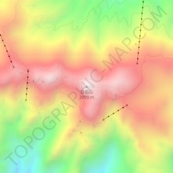
Name: 白石山 topographic map, elevation, terrain.
Location: 白石山, 保定市, 河北省, 中国 (39.21013 114.69571 39.21023 114.69581)
Average elevation: 5,318 ft
Minimum elevation: 3,560 ft
Maximum elevation: 6,739 ft
Make a donation
Gear up for your next adventure:
As an Amazon Associate, this site earns from qualifying purchases at no extra cost to you.
Other topographic maps
Click on a map to view its topography, its elevation and its terrain.
涞源县
东经114°20′-115°05′,北纬39°01′-39°40′,县域面积2448平方公里。太行山、燕山、恒山三山交汇,拒马河、易水、涞水三水同源。主要地形为山地,平均海拔在1000米以上,最高点为犁华尖,海拔2144米;涞源县城处于涞源盆地中心,平均海拔800-900米。涞源地处两省三市交界处(山西、河北,保定、张家口、大同)。省界,与山西省灵丘县接壤,途经南马庄、走马驿、水堡、北石佛、金家井、留家庄6个乡镇,南北界长97.5公里。市界,与张家口市蔚县相连,途经留家庄、上庄、东团堡3个乡,东西界长66.55公里。县界,东北接涞水县,途经东团堡、乌龙沟2个乡,南北界长23.65公里;东接易县,途经乌龙沟、塔崖驿、…
Average elevation: 3,323 ft
Make a donation
Gear up for your next adventure:
As an Amazon Associate, this site earns from qualifying purchases at no extra cost to you.
Make a donation
Gear up for your next adventure:
As an Amazon Associate, this site earns from qualifying purchases at no extra cost to you.
Make a donation
Gear up for your next adventure:
As an Amazon Associate, this site earns from qualifying purchases at no extra cost to you.
Make a donation
Gear up for your next adventure:
As an Amazon Associate, this site earns from qualifying purchases at no extra cost to you.
Make a donation
Gear up for your next adventure:
As an Amazon Associate, this site earns from qualifying purchases at no extra cost to you.
Make a donation
Gear up for your next adventure:
As an Amazon Associate, this site earns from qualifying purchases at no extra cost to you.
Make a donation
Gear up for your next adventure:
As an Amazon Associate, this site earns from qualifying purchases at no extra cost to you.
Make a donation
Gear up for your next adventure:
As an Amazon Associate, this site earns from qualifying purchases at no extra cost to you.