Geolocate

Indang topographic map

Click on the map to display elevation.

Indang

The topography of Indang is characterised by gently sloping or rolling terrain. Almost 40.36% of its total land area is within the slope grade of 3-8%, while 2,135 hectares is within the slope range of 8-15% which is characterised by undulating or sloping terrain.

About this map

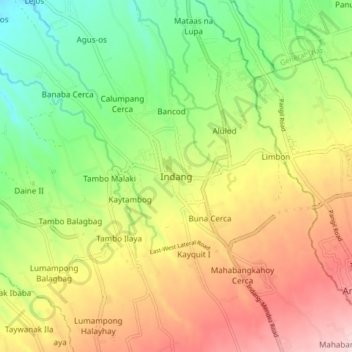
Name: Indang topographic map, elevation, terrain.

Location: Indang, Cavite, Calabarzon, 4122, Philippines (14.15584 120.83838 14.23584 120.91838)

Average elevation: 978 ft

Minimum elevation: 492 ft

Maximum elevation: 1,565 ft

Other topographic maps

Click on a map to view its topography, its elevation and its terrain.

Bancod

Philippines > Cavite > Indang

Average elevation: 791 ft

Mataas na Lupa (Checkpoint)

Philippines > Cavite > Indang

Average elevation: 738 ft

Kaytapos

Philippines > Cavite > Indang

Average elevation: 1,010 ft

Mataas na Lupa (Checkpoint)

Philippines > Cavite > Indang

Average elevation: 738 ft

Gear up for your next adventure:

🧯Portable Fire Pit - Compact fire pit for camping spots
🛠️Outdoor Gear Repair Kit - Essential tools to fix gear on the trail
📚USA Hiking Guide Books - Top trail guides and map books
☀️Outdoor Sunscreen - High protection sunscreen for outdoor activities
Backpacking Tent - Lightweight and durable tent for multi‑day hikes

As an Amazon Associate, this site earns from qualifying purchases at no extra cost to you.