
Horchheim topographic map
Click on the map to display elevation.
Horchheim
Koblenz-Horchheim ist ein Stadtteil von Koblenz. Er liegt auf der rechten Rheinseite zwischen Pfaffendorf und der Stadt Lahnstein. Horchheim wurde am 1. Juli 1937 in die Stadt Koblenz eingemeindet. Dazu gehörte auch der später neu geschaffene Stadtteil Horchheimer Höhe, der den gesamten ursprünglichen Horchheimer Wald beinhaltet und bis zur Stadtgrenze von Bad Ems (Denzer Heide) reicht. Von Horchheim aus führen die Horchheimer Eisenbahnbrücke und die Südbrücke über den Rhein nach Oberwerth.
About this map
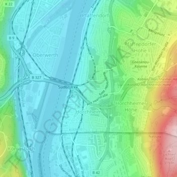
Name: Horchheim topographic map, elevation, terrain.
Location: Horchheim, Koblenz, Rheinland-Pfalz, 56076, Deutschland (50.32517 7.59039 50.33901 7.60646)
Average elevation: 417 ft
Minimum elevation: 197 ft
Maximum elevation: 1,083 ft
Other topographic maps
Click on a map to view its topography, its elevation and its terrain.
Koblenz
Deutschland > Rheinland-Pfalz > Koblenz
Koblenz liegt laut Angabe des Bundesamtes für Kartographie und Geodäsie auf 73 m ü. NHN. Das Deutsche Eck liegt bei 64,7 m Höhe. Die höchste vollständig im Stadtgebiet gelegene Erhebung ist mit 382 m der Kühkopf im Stadtwald. Die höchste Stelle des Stadtgebietes mit 385 m befindet sich auf der Grenze…
Average elevation: 787 ft