
Make a donation
Gear up for your next adventure:
As an Amazon Associate, this site earns from qualifying purchases at no extra cost to you.
Olaya topographic map
Click on the map to display elevation.
Make a donation
Gear up for your next adventure:
As an Amazon Associate, this site earns from qualifying purchases at no extra cost to you.
Olaya
Olaya is a town and municipality located in the western region of the Department of Antioquia in the Republic of Colombia. It borders to the north with the municipality of Liborina, to the east with the municipalities of Belmira and Sopetrán and to the South with Sopetrán and by the West with the municipality of Santa Fe de Antioquia. It lies at an altitude of 500 m (1,600 ft) above sea level.
Make a donation
Gear up for your next adventure:
As an Amazon Associate, this site earns from qualifying purchases at no extra cost to you.
About this map
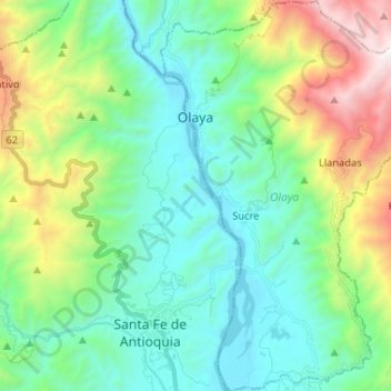
Name: Olaya topographic map, elevation, terrain.
Average elevation: 3,123 ft
Minimum elevation: 1,362 ft
Maximum elevation: 8,068 ft
Make a donation
Gear up for your next adventure:
As an Amazon Associate, this site earns from qualifying purchases at no extra cost to you.