Geolocate

Coqueiro Seco topographic map

Click on the map to display elevation.

Coqueiro Seco

The history account that some years later came to the region several missionaries of the order of Franciscans, which delighted up with the topography of the place, which had plans ups and downs, changing its name to Monte Santo. Get accustomed with the old name of the city, the people ignored the Franciscans and retained the name of Coqueiro Seco.

Wikipedia (CC-BY-SA 3.0)

About this map

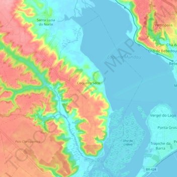
Name: Coqueiro Seco topographic map, elevation, terrain.

Location: Coqueiro Seco, Região Geográfica Imediata de Maceió, Região Geográfica Intermediária de Maceió, Alagoas, Northeast Region, Brazil (-9.68058 -35.86768 -9.60014 -35.76900)

Average elevation: 121 ft

Minimum elevation: -10 ft

Maximum elevation: 364 ft

Gear up for your next adventure:

💧Water Purification System - Clean water on the trail with reliable purifiers
🥤Water Filter Bottle - All‑in‑one filter bottle for safe hydration
📱Solar Portable Charger - Solar power bank for charging devices off‑grid
👟Trail Running Shoes - Lightweight shoes for trail runners
🧺Microfiber Travel Towels - Compact and fast-drying towels for trail use

As an Amazon Associate, this site earns from qualifying purchases at no extra cost to you.