
Make a donation
Gear up for your next adventure:
As an Amazon Associate, this site earns from qualifying purchases at no extra cost to you.
Elzer Berg topographic map
Click on the map to display elevation.
Make a donation
Gear up for your next adventure:
As an Amazon Associate, this site earns from qualifying purchases at no extra cost to you.
Elzer Berg
Der Elzer Berg gehört in der naturräumlichen Haupteinheitengruppe Westerwald (Nr. 32), in der Haupteinheit Niederwesterwald (324) und in der Untereinheit Emsbach-Gelbach-Höhen (324.0) zum Naturraum Eppenroder Hochfläche (324.04). Über seinen Ostausläufer Heidekopf (250 m) fällt die Landschaft in den Naturraum Hadamar-Elzer Beckenrand (311.01) ab, der in der Haupteinheitengruppe Gießen-Koblenzer Lahntal (31) und in der Haupteinheit Limburger Becken (311) zur Untereinheit Inneres Limburger Becken (311.1) zählt.
Make a donation
Gear up for your next adventure:
As an Amazon Associate, this site earns from qualifying purchases at no extra cost to you.
About this map
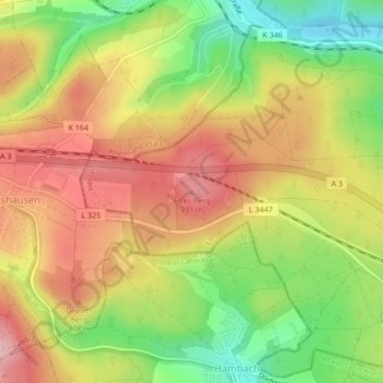
Name: Elzer Berg topographic map, elevation, terrain.
Average elevation: 781 ft
Minimum elevation: 479 ft
Maximum elevation: 1,043 ft
Make a donation
Gear up for your next adventure:
As an Amazon Associate, this site earns from qualifying purchases at no extra cost to you.
Other topographic maps
Click on a map to view its topography, its elevation and its terrain.