
Make a donation
Gear up for your next adventure:
As an Amazon Associate, this site earns from qualifying purchases at no extra cost to you.
Lake Billy Chinook topographic map
Click on the map to display elevation.
Make a donation
Gear up for your next adventure:
As an Amazon Associate, this site earns from qualifying purchases at no extra cost to you.
About this map
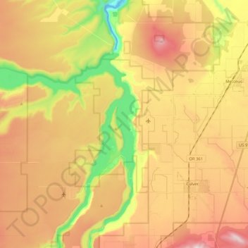
Name: Lake Billy Chinook topographic map, elevation, terrain.
Average elevation: 2,546 ft
Minimum elevation: 1,581 ft
Maximum elevation: 3,412 ft
Jefferson County trails, hiking, mountain biking, running and outdoor activities
Make a donation
Gear up for your next adventure:
As an Amazon Associate, this site earns from qualifying purchases at no extra cost to you.
Other topographic maps
Click on a map to view its topography, its elevation and its terrain.
Suttle Lake
United States > Oregon > Jefferson County
Suttle Lake is located near the crest of the Cascade Mountains in western Jefferson County, Oregon. Its elevation is 3,438 feet (1,048 m) above sea level. The lake is surrounded by the Deschutes National Forest. The lake is 13 miles (21 km) west of Sisters, Oregon and 90 miles (140 km) east of Salem, in the…
Average elevation: 3,671 ft
Peter Skene Ogden State Scenic Viewport
United States > Oregon > Jefferson County
Average elevation: 2,753 ft
Make a donation
Gear up for your next adventure:
As an Amazon Associate, this site earns from qualifying purchases at no extra cost to you.