
Thank you for supporting this site ❤️
Make a donation
Make a donation
Gear up for your next adventure:
As an Amazon Associate, this site earns from qualifying purchases at no extra cost to you.
Harinsart topographic map
Click on the map to display elevation.
Thank you for supporting this site ❤️
Make a donation
Make a donation
Gear up for your next adventure:
As an Amazon Associate, this site earns from qualifying purchases at no extra cost to you.
About this map
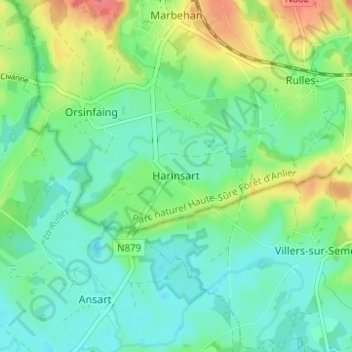
Name: Harinsart topographic map, elevation, terrain.
Location: Harinsart, Habay, Virton, Luxembourg, Wallonie, 6724, Belgique (49.68724 5.51616 49.72724 5.55616)
Average elevation: 1,129 ft
Minimum elevation: 1,060 ft
Maximum elevation: 1,276 ft
Thank you for supporting this site ❤️
Make a donation
Make a donation
Gear up for your next adventure:
As an Amazon Associate, this site earns from qualifying purchases at no extra cost to you.