
Make a donation
Gear up for your next adventure:
As an Amazon Associate, this site earns from qualifying purchases at no extra cost to you.
El Madher topographic map
Click on the map to display elevation.
Make a donation
Gear up for your next adventure:
As an Amazon Associate, this site earns from qualifying purchases at no extra cost to you.
El Madher
Le territoire de la commune se trouve à plus de 1 100 m d'altitude au pied du mont Bouarif, près du Kef Lahmar (le rocher rouge).
Make a donation
Gear up for your next adventure:
As an Amazon Associate, this site earns from qualifying purchases at no extra cost to you.
About this map
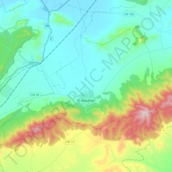
Name: El Madher topographic map, elevation, terrain.
Location: El Madher, Daïra El Madher, Batna, 05015, Algérie (35.58463 6.27081 35.69406 6.47163)
Average elevation: 3,465 ft
Minimum elevation: 2,703 ft
Maximum elevation: 5,715 ft
Make a donation
Gear up for your next adventure:
As an Amazon Associate, this site earns from qualifying purchases at no extra cost to you.