
Make a donation
Gear up for your next adventure:
As an Amazon Associate, this site earns from qualifying purchases at no extra cost to you.
Merchingen topographic map
Click on the map to display elevation.
Make a donation
Gear up for your next adventure:
As an Amazon Associate, this site earns from qualifying purchases at no extra cost to you.
Merchingen
Die Gesamtgröße der Gemarkung beträgt 943 ha, davon sind 238 ha Wald. Landwirtschaftlich werden 634 ha genutzt. Das Naturschutzgebiet Geißenfels umfasst 17 ha, die Wasserfläche des Dorfes insgesamt 9,7 ha. Es liegen an wertvoller Biotopfläche 148 ha vor. Die höchste Erhebung weist eine Höhe von 417 m ü. NHN auf. Im Jahre 2004 wurden gegen das Votum der kommunalen Gremien 340 ha Fläche als Vorranggebiete für Windenergieanlagen definiert.
Make a donation
Gear up for your next adventure:
As an Amazon Associate, this site earns from qualifying purchases at no extra cost to you.
About this map
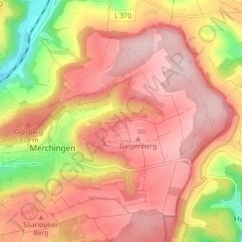
Name: Merchingen topographic map, elevation, terrain.
Average elevation: 1,112 ft
Minimum elevation: 610 ft
Maximum elevation: 1,394 ft
Make a donation
Gear up for your next adventure:
As an Amazon Associate, this site earns from qualifying purchases at no extra cost to you.