
Make a donation
Gear up for your next adventure:
As an Amazon Associate, this site earns from qualifying purchases at no extra cost to you.
Drais topographic map
Click on the map to display elevation.
Make a donation
Gear up for your next adventure:
As an Amazon Associate, this site earns from qualifying purchases at no extra cost to you.
Drais
Er ist mit rund 3200 Einwohnern und 308 Hektar Ortsfläche der kleinste Ortsbezirk der Stadt. Drais wurde 1969 zusammen mit fünf weiteren Vororten als neuer Stadtteil eingemeindet. Drais liegt auf einer Anhöhe über Mainz und befindet sich im südwestlichen Stadtgebiet. Drais ist vor allem von Obst- und Gemüseanbau (Kirschen, Spargel, Erdbeeren) geprägt. Aufgrund seiner Weitsichtlagen ist Drais als Wohnort beliebt.
Make a donation
Gear up for your next adventure:
As an Amazon Associate, this site earns from qualifying purchases at no extra cost to you.
About this map
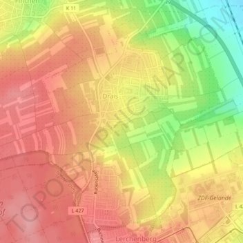
Name: Drais topographic map, elevation, terrain.
Location: Drais, Mainz, Rheinland-Pfalz, Deutschland (49.96027 8.17830 49.98333 8.20980)
Average elevation: 663 ft
Minimum elevation: 440 ft
Maximum elevation: 781 ft
Make a donation
Gear up for your next adventure:
As an Amazon Associate, this site earns from qualifying purchases at no extra cost to you.
Other topographic maps
Click on a map to view its topography, its elevation and its terrain.
Mainz
Deutschland > Rheinland-Pfalz > Mainz
Mainz befindet sich auf einer Höhe von 82 bis 245 m ü. NN. Die Stadt liegt am westlichen (linken) Ufer des Rheins, der die östliche Stadtgrenze bildet, mit Rheinkilometer 500 ungefähr auf halbem Wege zwischen Bodensee und Nordsee. Im Süden und Westen wird die Stadt im Mainzer Becken vom Rande der…
Average elevation: 600 ft
Make a donation
Gear up for your next adventure:
As an Amazon Associate, this site earns from qualifying purchases at no extra cost to you.