
Make a donation
Gear up for your next adventure:
As an Amazon Associate, this site earns from qualifying purchases at no extra cost to you.
Parque Romero topographic map
Click on the map to display elevation.
Make a donation
Gear up for your next adventure:
As an Amazon Associate, this site earns from qualifying purchases at no extra cost to you.
About this map
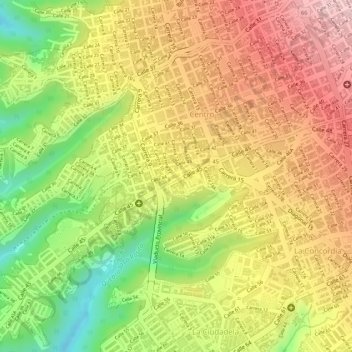
Name: Parque Romero topographic map, elevation, terrain.
Location: Parque Romero, Bucaramanga, Metropolitana, Santander, Colombia (7.11296 -73.12874 7.11379 -73.12787)
Average elevation: 3,038 ft
Minimum elevation: 2,618 ft
Maximum elevation: 3,346 ft
Make a donation
Gear up for your next adventure:
As an Amazon Associate, this site earns from qualifying purchases at no extra cost to you.
Other topographic maps
Click on a map to view its topography, its elevation and its terrain.
Bucaramanga
Colombia > Santander > Bucaramanga
El área de Bucaramanga total es de 162 km²; las diferentes altitudes de algunos puntos del suelo permiten que la ciudad se encuentre en varios pisos térmicos que se distribuyen en cálido 55 km², medio 100 km² (donde yace el área urbana con 34 km²) y frío 10 km².
Average elevation: 4,423 ft