
Thank you for supporting this site ❤️
Make a donation
Make a donation
Gear up for your next adventure:
As an Amazon Associate, this site earns from qualifying purchases at no extra cost to you.
Nerín topographic map
Click on the map to display elevation.
Thank you for supporting this site ❤️
Make a donation
Make a donation
Gear up for your next adventure:
As an Amazon Associate, this site earns from qualifying purchases at no extra cost to you.
About this map
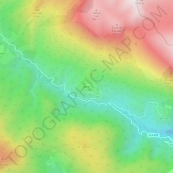
Name: Nerín topographic map, elevation, terrain.
Location: Nerín, Fanlo, Sobrarbe, Huesca, Aragon, 22375, Espagne (42.55393 -0.00314 42.59393 0.03686)
Average elevation: 4,633 ft
Minimum elevation: 3,159 ft
Maximum elevation: 6,512 ft
Thank you for supporting this site ❤️
Make a donation
Make a donation
Gear up for your next adventure:
As an Amazon Associate, this site earns from qualifying purchases at no extra cost to you.