
Thank you for supporting this site ❤️
Make a donation
Make a donation
Gear up for your next adventure:
As an Amazon Associate, this site earns from qualifying purchases at no extra cost to you.
Klosterneuburg topographic map
Click on the map to display elevation.
Thank you for supporting this site ❤️
Make a donation
Make a donation
Gear up for your next adventure:
As an Amazon Associate, this site earns from qualifying purchases at no extra cost to you.
About this map
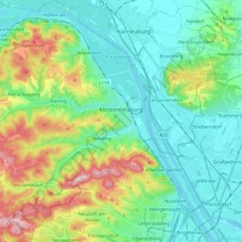
Name: Klosterneuburg topographic map, elevation, terrain.
Location: Klosterneuburg, Bezirk Tulln, Lower Austria, 3400, Austria (48.23832 16.20148 48.35954 16.36318)
Average elevation: 827 ft
Minimum elevation: 505 ft
Maximum elevation: 1,713 ft
Thank you for supporting this site ❤️
Make a donation
Make a donation
Gear up for your next adventure:
As an Amazon Associate, this site earns from qualifying purchases at no extra cost to you.
Other topographic maps
Click on a map to view its topography, its elevation and its terrain.