
Thank you for supporting this site ❤️
Make a donation
Make a donation
Gear up for your next adventure:
As an Amazon Associate, this site earns from qualifying purchases at no extra cost to you.
Chaguarpamba topographic map
Click on the map to display elevation.
Thank you for supporting this site ❤️
Make a donation
Make a donation
Gear up for your next adventure:
As an Amazon Associate, this site earns from qualifying purchases at no extra cost to you.
About this map
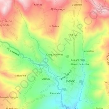
Name: Chaguarpamba topographic map, elevation, terrain.
Location: Chaguarpamba, Deleg, Cañar, Ecuador (-2.78374 -78.94501 -2.74374 -78.90501)
Average elevation: 9,124 ft
Minimum elevation: 8,425 ft
Maximum elevation: 9,882 ft
Thank you for supporting this site ❤️
Make a donation
Make a donation
Gear up for your next adventure:
As an Amazon Associate, this site earns from qualifying purchases at no extra cost to you.