
Make a donation
Gear up for your next adventure:
As an Amazon Associate, this site earns from qualifying purchases at no extra cost to you.
Indian Springs topographic map
Click on the map to display elevation.
Make a donation
Gear up for your next adventure:
As an Amazon Associate, this site earns from qualifying purchases at no extra cost to you.
Indian Springs
Terrain in the area is generally rugged with elevations between 600 and 1,900 feet (580 m) above sea level, the landscape being primarily wooded. The terrain here differs greatly from the neighboring Hagerstown Valley, where elevations average less than 650' and is characterized by fertile, gently rolling hills. While land for farming is not as readily available in the Springs area, orchards have been a source of local livelihood for centuries.
Make a donation
Gear up for your next adventure:
As an Amazon Associate, this site earns from qualifying purchases at no extra cost to you.
About this map
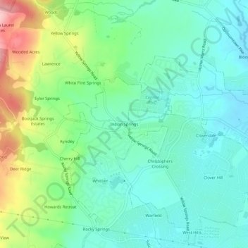
Name: Indian Springs topographic map, elevation, terrain.
Average elevation: 469 ft
Minimum elevation: 308 ft
Maximum elevation: 873 ft
Frederick County trails, hiking, mountain biking, running and outdoor activities
Make a donation
Gear up for your next adventure:
As an Amazon Associate, this site earns from qualifying purchases at no extra cost to you.