
Make a donation
Gear up for your next adventure:
As an Amazon Associate, this site earns from qualifying purchases at no extra cost to you.
Holeta Genet topographic map
Click on the map to display elevation.
Make a donation
Gear up for your next adventure:
As an Amazon Associate, this site earns from qualifying purchases at no extra cost to you.
Holeta Genet
Holeta (Amharic: ሆለታ) (Oromo: Holataa) is a town in the special zone of Oromia Region, Ethiopia. It has a latitude and longitude of 9°3′N 38°30′E / 9.050°N 38.500°E / 9.050; 38.500 and an altitude of 2391 meters above sea level.
Make a donation
Gear up for your next adventure:
As an Amazon Associate, this site earns from qualifying purchases at no extra cost to you.
About this map
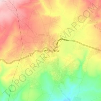
Name: Holeta Genet topographic map, elevation, terrain.
Location: Holeta Genet, Walmara, West Shewa, Oromia Region, Ethiopia (9.02525 38.45368 9.10525 38.53368)
Average elevation: 7,844 ft
Minimum elevation: 7,306 ft
Maximum elevation: 8,356 ft
Make a donation
Gear up for your next adventure:
As an Amazon Associate, this site earns from qualifying purchases at no extra cost to you.