
Make a donation
Gear up for your next adventure:
As an Amazon Associate, this site earns from qualifying purchases at no extra cost to you.
Bristol topographic map
Click on the map to display elevation.
Make a donation
Gear up for your next adventure:
As an Amazon Associate, this site earns from qualifying purchases at no extra cost to you.
About this map
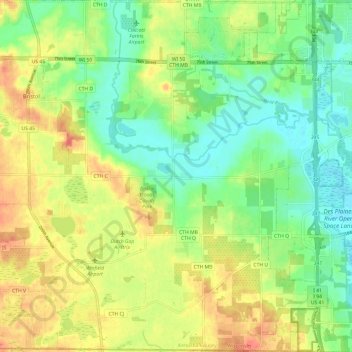
Name: Bristol topographic map, elevation, terrain.
Location: Bristol, Kenosha County, Wisconsin, 53104, United States (42.49465 -88.06998 42.58304 -87.95104)
Average elevation: 774 ft
Minimum elevation: 673 ft
Maximum elevation: 883 ft
Kenosha County trails, hiking, mountain biking, running and outdoor activities
Make a donation
Gear up for your next adventure:
As an Amazon Associate, this site earns from qualifying purchases at no extra cost to you.
Other topographic maps
Click on a map to view its topography, its elevation and its terrain.
Pleasant Prairie
United States > Wisconsin > Kenosha County > Pleasant Prairie
Average elevation: 715 ft