
Bath topographic map
Interactive map
Click on the map to display elevation.
About this map
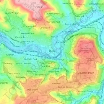
Name: Bath topographic map, elevation, terrain.
Average elevation: 328 ft
Minimum elevation: 46 ft
Maximum elevation: 771 ft
Bath is in the Avon Valley and is surrounded by limestone hills as it is near the southern edge of the Cotswolds, a designated Area of Outstanding Natural Beauty, and the limestone Mendip Hills rise around 7 miles (11 km) south of the city. The hills that surround and make up the city have a maximum altitude of 781 feet (238 metres) on the Lansdown plateau. Bath has an area of 11 square miles (28 square kilometres).
Other topographic maps
Click on a map to view its topography, its elevation and its terrain.
Old Mills
United Kingdom > England > Bath and North East Somerset > Paulton
Old Mills, Paulton, Bath and North East Somerset, West of England, England, BS39 7SR, United Kingdom
Average elevation: 413 ft
River Kennet
United Kingdom > England > Bath and North East Somerset
River Kennet, Bath and North East Somerset, West of England, England, RG1 6BT, United Kingdom, Kennet and Avon Canal
Average elevation: 154 ft
Clandown
United Kingdom > England > Bath and North East Somerset > Radstock
Clandown, Radstock, Bath and North East Somerset, West of England, England, BA3 3DW, United Kingdom
Average elevation: 387 ft
Peasedown St. John
United Kingdom > England > Bath and North East Somerset
Peasedown St. John, Bath and North East Somerset, West of England, England, United Kingdom
Average elevation: 410 ft
Batheaston
United Kingdom > England > Bath and North East Somerset > Batheaston
Batheaston, Bath and North East Somerset, West of England, England, United Kingdom
Average elevation: 374 ft
Chew Magna
United Kingdom > England > Bath and North East Somerset > Chew Magna
Chew Magna, Bath and North East Somerset, West of England, England, United Kingdom
Average elevation: 295 ft
Monkton Combe
United Kingdom > England > Bath and North East Somerset
Monkton Combe, Bath and North East Somerset, West of England, England, United Kingdom
Average elevation: 335 ft