
Torrington topographic map
Click on the map to display elevation.
Torrington
Torrington is located at 42°4′0″N 104°10′57″W / 42.06667°N 104.18250°W / 42.06667; -104.18250 (42.066542, −104.182471). According to the United States Census Bureau, the city has a total area of 4.62 square miles (11.97 km2), all land. Its elevation is 4,104 feet (1,251 meters).
About this map
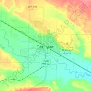
Name: Torrington topographic map, elevation, terrain.
Location: Torrington, Goshen County, Wyoming, United States (42.03860 -104.21911 42.08836 -104.09340)
Average elevation: 4,154 ft
Minimum elevation: 4,052 ft
Maximum elevation: 4,321 ft
Goshen County trails, hiking, mountain biking, running and outdoor activities
Other topographic maps
Click on a map to view its topography, its elevation and its terrain.
Goshen County Fair Grounds
United States > Wyoming > Goshen County > Torrington
Average elevation: 4,127 ft