Geolocate

Troy topographic map

Click on the map to display elevation.

About this map

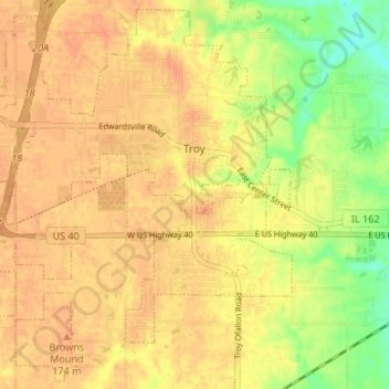
Name: Troy topographic map, elevation, terrain.

Location: Troy, Madison County, Illinois, 62294, United States (38.69798 -89.93313 38.74791 -89.86634)

Average elevation: 545 ft

Minimum elevation: 459 ft

Maximum elevation: 584 ft

Madison County trails, hiking, mountain biking, running and outdoor activities

Other topographic maps

Click on a map to view its topography, its elevation and its terrain.

North Venice

United States > Illinois > Madison County > Venice

Average elevation: 413 ft

North Alton

United States > Illinois > Madison County > Godfrey

Average elevation: 587 ft

Bethalto

United States > Illinois > Madison County > Bethalto > Bethalto

Average elevation: 512 ft

Alton

United States > Illinois > Madison County > Alton

Average elevation: 482 ft

Gear up for your next adventure:

🧭GPS Watch Accessories - Bands and chargers for GPS watches
🧯Portable Fire Pit - Compact fire pit for camping spots
📶Satellite Messenger - Communication device off‑grid
☀️Outdoor Sunscreen - High protection sunscreen for outdoor activities
👓Polarized Sunglasses - Outdoor sunglasses for glare reduction

As an Amazon Associate, this site earns from qualifying purchases at no extra cost to you.