
Thank you for supporting this site ❤️
Make a donation
Make a donation
Gear up for your next adventure:
As an Amazon Associate, this site earns from qualifying purchases at no extra cost to you.
Shaunavon topographic map
Click on the map to display elevation.
Thank you for supporting this site ❤️
Make a donation
Make a donation
Gear up for your next adventure:
As an Amazon Associate, this site earns from qualifying purchases at no extra cost to you.
About this map
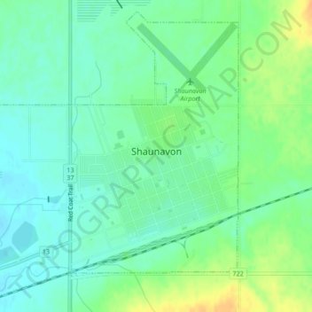
Name: Shaunavon topographic map, elevation, terrain.
Location: Shaunavon, Division No. 4, Saskatchewan, S0N 2M0, Canada (49.63783 -108.43292 49.66287 -108.39909)
Average elevation: 3,022 ft
Minimum elevation: 2,986 ft
Maximum elevation: 3,084 ft
Thank you for supporting this site ❤️
Make a donation
Make a donation
Gear up for your next adventure:
As an Amazon Associate, this site earns from qualifying purchases at no extra cost to you.