Geolocate

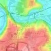
77700 topographic map

Click on the map to display elevation.

About this map

Name: 77700 topographic map, elevation, terrain.

Location: 77700, Coupvray, Torcy, Seine-et-Marne, Île-de-France, France métropolitaine, France (48.86906 2.79480 48.86916 2.79490)

Average elevation: 413 ft

Minimum elevation: 331 ft

Maximum elevation: 446 ft

Other topographic maps

Click on a map to view its topography, its elevation and its terrain.
Le Bourg Ancien

France > Île-de-France > Seine-et-Marne > Coupvray

Average elevation: 285 ft

Gear up for your next adventure:

🗻Climbing Gear Basics - Essential gear for beginner climbers
🔦Powerful Headlamps - Ultra-bright hands-free lighting for night navigation
⌚GPS Sports Watch - GPS watch for running, hiking and training
🥾Hiking Shoes - Durable and comfortable shoes for trail hiking
📷Action Camera - Capture your outdoor adventures in HD

As an Amazon Associate, this site earns from qualifying purchases at no extra cost to you.