
Make a donation
Gear up for your next adventure:
As an Amazon Associate, this site earns from qualifying purchases at no extra cost to you.
Pena Park topographic map
Click on the map to display elevation.
Make a donation
Gear up for your next adventure:
As an Amazon Associate, this site earns from qualifying purchases at no extra cost to you.
About this map
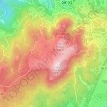
Name: Pena Park topographic map, elevation, terrain.
Average elevation: 1,027 ft
Minimum elevation: 246 ft
Maximum elevation: 1,647 ft
Make a donation
Gear up for your next adventure:
As an Amazon Associate, this site earns from qualifying purchases at no extra cost to you.
Other topographic maps
Click on a map to view its topography, its elevation and its terrain.
Make a donation
Gear up for your next adventure:
As an Amazon Associate, this site earns from qualifying purchases at no extra cost to you.
Negrais
Portugal > Lisbon > Sintra > Almargem do Bispo, Pêro Pinheiro e Montelavar
Average elevation: 702 ft
Alfouvar de Cima
Portugal > Lisbon > Sintra > Almargem do Bispo, Pêro Pinheiro e Montelavar
Average elevation: 633 ft