Geolocate

Ulverstone topographic map

Click on the map to display elevation.

About this map

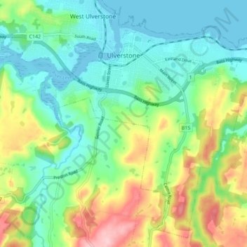
Name: Ulverstone topographic map, elevation, terrain.

Location: Ulverstone, Central Coast, Tasmania, 7315, Australia (-41.20457 146.14333 -41.14525 146.22841)

Average elevation: 197 ft

Minimum elevation: -20 ft

Maximum elevation: 614 ft

Gear up for your next adventure:

🎒Trekking Poles - Sturdy poles for balance and stability on rough terrain
🚑Emergency Bivvies - Heat-reflective sleeping bags for survival situations
📷Action Camera - Capture your outdoor adventures in HD
📦Dry Bags Set - Waterproof storage for electronics and clothes
🚗GPS Dash Cams - Record your scenic drives through mountain passes and canyons

As an Amazon Associate, this site earns from qualifying purchases at no extra cost to you.