
Make a donation
Gear up for your next adventure:
As an Amazon Associate, this site earns from qualifying purchases at no extra cost to you.
Laufen-Uhwiesen topographic map
Click on the map to display elevation.
Make a donation
Gear up for your next adventure:
As an Amazon Associate, this site earns from qualifying purchases at no extra cost to you.
Laufen-Uhwiesen
The municipality is located on the edge of the Schaffhausen Agglomeration, though it is in the canton of Zürich. It includes the village of Uhwiesen, which is located on a terrace of the Cholfirst elevation, the village of Laufen with Laufen Castle on the Rhine Falls, and the hamlet of Nohl on the right bank of the Rhine. Until 1840, it was part of the municipality of Flurlingen.
Make a donation
Gear up for your next adventure:
As an Amazon Associate, this site earns from qualifying purchases at no extra cost to you.
About this map
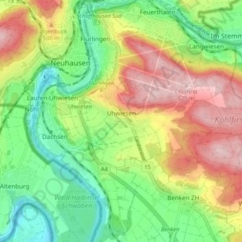
Name: Laufen-Uhwiesen topographic map, elevation, terrain.
Location: Laufen-Uhwiesen, Bezirk Andelfingen, Zurich, 8248, Switzerland (47.65985 8.60614 47.67883 8.67904)
Average elevation: 1,467 ft
Minimum elevation: 1,148 ft
Maximum elevation: 1,880 ft
Make a donation
Gear up for your next adventure:
As an Amazon Associate, this site earns from qualifying purchases at no extra cost to you.