
Thank you for supporting this site ❤️
Make a donation
Make a donation
Gear up for your next adventure:
As an Amazon Associate, this site earns from qualifying purchases at no extra cost to you.
Pashupati topographic map
Click on the map to display elevation.
Thank you for supporting this site ❤️
Make a donation
Make a donation
Gear up for your next adventure:
As an Amazon Associate, this site earns from qualifying purchases at no extra cost to you.
About this map
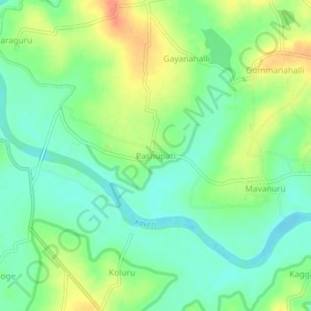
Name: Pashupati topographic map, elevation, terrain.
Location: Pashupati, Saligrama taluku, Mysuru, Karnataka, 573136, India (12.52391 76.18205 12.56391 76.22205)
Average elevation: 2,651 ft
Minimum elevation: 2,589 ft
Maximum elevation: 2,740 ft
Thank you for supporting this site ❤️
Make a donation
Make a donation
Gear up for your next adventure:
As an Amazon Associate, this site earns from qualifying purchases at no extra cost to you.