
Frozen Head State Park topographic map
Interactive map
Click on the map to display elevation.
About this map
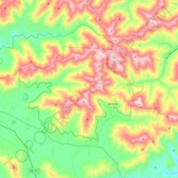
Name: Frozen Head State Park topographic map, elevation, terrain.
Average elevation: 1,900 ft
Minimum elevation: 830 ft
Maximum elevation: 3,317 ft
Frozen Head State Park consists of approximately 24,000 acres (97 km2), all but 330 acres (1.3 km2) of which is classified as a state natural area. The terrain varies between 1,300 ft (400 m) to over 3,000 ft (910 m) with 14 peaks at or over 3,000 feet (910 m). Frozen Head, the park's namesake, is the highest peak at 3,324 feet (1,013 m). The mountain's name comes from its snow-capped appearance in colder months. The park's highest elevations allow for unobstructed views of East Tennessee's three main physiographic features: the Cumberland Plateau, the Tennessee Valley, and across the valley, the Great Smoky Mountains.
Other topographic maps
Click on a map to view its topography, its elevation and its terrain.
Petros
United States > Tennessee > Morgan County
Petros, Morgan County, East Tennessee, Tennessee, 37545, United States
Average elevation: 1,850 ft
Elizabeth
United States > Tennessee > Morgan County
Elizabeth, Morgan County, East Tennessee, Tennessee, United States
Average elevation: 1,309 ft
Rugby
United States > Tennessee > Morgan County
Rugby, Morgan County, Tennessee, 37733, United States
Average elevation: 1,355 ft
Chimney Top Mountain
United States > Tennessee > Morgan County
Chimney Top Mountain, Morgan County, Tennessee, United States
Average elevation: 2,201 ft
White Creek
United States > Tennessee > Morgan County
White Creek, Morgan County, Tennessee, United States
Average elevation: 1,467 ft
Pilot Mountain
United States > Tennessee > Morgan County
Pilot Mountain, Morgan County, Tennessee, United States
Average elevation: 1,654 ft
Deer Lodge
United States > Tennessee > Morgan County > Deer Lodge
Deer Lodge, Morgan County, Tennessee, United States
Average elevation: 1,529 ft
Grove
United States > Tennessee > Morgan County
Grove, Morgan County, Tennessee, 37887, United States
Average elevation: 1,493 ft
Sunbright
United States > Tennessee > Morgan County
Sunbright, Morgan County, East Tennessee, Tennessee, United States
Average elevation: 1,440 ft
Lancing
United States > Tennessee > Morgan County
Lancing, Morgan County, East Tennessee, Tennessee, 37770, United States
Average elevation: 1,283 ft
Cooke Knob
United States > Tennessee > Morgan County
Cooke Knob, Morgan County, Tennessee, 37749, United States
Average elevation: 1,191 ft
Oakdale
United States > Tennessee > Morgan County > Oakdale > Oakdale
Oakdale, Morgan County, Tennessee, 37749, United States
Average elevation: 1,119 ft
Coalfield
United States > Tennessee > Morgan County > Coalfield
Coalfield, Morgan County, Tennessee, 37740, United States
Average elevation: 1,093 ft
Wartburg
United States > Tennessee > Morgan County
Wartburg, Morgan County, East Tennessee, Tennessee, United States
Average elevation: 1,325 ft