
Eva Lake Park topographic map
Interactive map
Click on the map to display elevation.
About this map
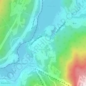
Name: Eva Lake Park topographic map, elevation, terrain.
Average elevation: 2,493 ft
Minimum elevation: 2,060 ft
Maximum elevation: 4,104 ft
Other topographic maps
Click on a map to view its topography, its elevation and its terrain.
Nita Lake
Canada > British Columbia > Squamish-Lillooet Regional District > Whistler Resort Municipality
Nita Lake, Creekside Village, Whistler Creekside, Whistler Resort Municipality, Squamish-Lillooet Regional District, British Columbia, Canada
Average elevation: 2,457 ft
Alta Lake
Canada > British Columbia > Squamish-Lillooet Regional District > Whistler Resort Municipality > Whistler Village
Alta Lake, Nordic, Whistler Village, Whistler Resort Municipality, Squamish-Lillooet Regional District, British Columbia, Canada
Average elevation: 2,379 ft
Whistler Village
Canada > British Columbia > Squamish-Lillooet Regional District > Whistler Resort Municipality
Whistler Village, Whistler Resort Municipality, Squamish-Lillooet Regional District, British Columbia, V8E 1M3, Canada
Average elevation: 2,543 ft
Lost Lake
Canada > British Columbia > Squamish-Lillooet Regional District > Whistler Resort Municipality > Whistler Village
Lost Lake, Whistler Village, Whistler Resort Municipality, Squamish-Lillooet Regional District, British Columbia, Canada
Average elevation: 2,543 ft