
Make a donation
Gear up for your next adventure:
As an Amazon Associate, this site earns from qualifying purchases at no extra cost to you.
Campinho topographic map
Click on the map to display elevation.
Make a donation
Gear up for your next adventure:
As an Amazon Associate, this site earns from qualifying purchases at no extra cost to you.
About this map
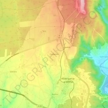
Name: Campinho topographic map, elevation, terrain.
Average elevation: 407 ft
Minimum elevation: 43 ft
Maximum elevation: 705 ft
Make a donation
Gear up for your next adventure:
As an Amazon Associate, this site earns from qualifying purchases at no extra cost to you.
Other topographic maps
Click on a map to view its topography, its elevation and its terrain.
Branca
Portugal > Aveiro > Albergaria-a-Velha
A freguesia da Branca possuí uma geografia acidentada. A Oeste, a freguesia é ocupada sobretudo por uma planície com altitudes variáveis entre os 70 e os 110 metros. E a este, a freguesia é cortada de norte a sul pela serra de São Julião, que atinge uma altitude máxima de 333 metros. Na sua fronteira a…
Average elevation: 459 ft
Make a donation
Gear up for your next adventure:
As an Amazon Associate, this site earns from qualifying purchases at no extra cost to you.