
Chahardi topographic map
Interactive map
Click on the map to display elevation.
About this map
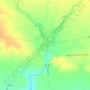
Name: Chahardi topographic map, elevation, terrain.
Location: Chahardi, Chopda, Jalgaon, Maharashtra, 425107, India (21.20101 75.21015 21.24101 75.25015)
Average elevation: 597 ft
Minimum elevation: 538 ft
Maximum elevation: 646 ft
Other topographic maps
Click on a map to view its topography, its elevation and its terrain.
Gul
India > Maharashtra > Chopda > Ambade
Gul, Ambade, Chopda, Jalgaon, Maharashtra, India
Average elevation: 702 ft
Adavad
India > Maharashtra > Chopda
Adavad, Chopda, Jalgaon, Maharashtra, 425303, India
Average elevation: 640 ft
Majare Hol
India > Maharashtra > Chopda
Majare Hol, Chopda, Jalgaon, Maharashtra, 425107, India
Average elevation: 587 ft