
Monte Piana topographic map
Interactive map
Click on the map to display elevation.
About this map
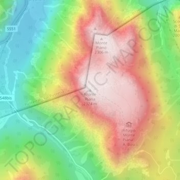
Name: Monte Piana topographic map, elevation, terrain.
Location: Monte Piana, Auronzo di Cadore, Belluno, Veneto, Italy (46.61581 12.24262 46.61591 12.24272)
Average elevation: 6,070 ft
Minimum elevation: 4,600 ft
Maximum elevation: 7,618 ft
Other topographic maps
Click on a map to view its topography, its elevation and its terrain.
Misurina
Italy > Veneto > Belluno > Auronzo di Cadore
Misurina, Auronzo di Cadore, Belluno, Veneto, Italy
Average elevation: 6,411 ft
Zwölferkofel - Croda dei Toni
Italy > Veneto > Belluno > Auronzo di Cadore
Zwölferkofel - Croda dei Toni, Auronzo di Cadore, Belluno, Veneto, Italy
Average elevation: 7,766 ft
Tre Cime di Lavaredo - Drei Zinnen
Italy > Veneto > Belluno > Auronzo di Cadore
Tre Cime di Lavaredo - Drei Zinnen, Auronzo di Cadore, Pustertal - Val Pusteria, Belluno, Veneto, 39034, Italy
Average elevation: 7,356 ft