
Thank you for supporting this site ❤️
Make a donation
Make a donation
Gear up for your next adventure:
As an Amazon Associate, this site earns from qualifying purchases at no extra cost to you.
Shovi topographic map
Click on the map to display elevation.
Thank you for supporting this site ❤️
Make a donation
Make a donation
Gear up for your next adventure:
As an Amazon Associate, this site earns from qualifying purchases at no extra cost to you.
About this map
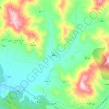
Name: Shovi topographic map, elevation, terrain.
Location: Shovi, بخش مرکزی, Baneh County, Kurdistan Province, Iran (36.00829 45.82219 36.08829 45.90219)
Average elevation: 5,371 ft
Minimum elevation: 4,623 ft
Maximum elevation: 6,942 ft
Thank you for supporting this site ❤️
Make a donation
Make a donation
Gear up for your next adventure:
As an Amazon Associate, this site earns from qualifying purchases at no extra cost to you.