
Gornje Polje topographic map
Interactive map
Click on the map to display elevation.
About this map
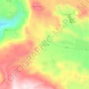
Name: Gornje Polje topographic map, elevation, terrain.
Location: Gornje Polje, Nikšić Municipality, Montenegro (42.63867 18.59502 42.67867 18.63502)
Average elevation: 2,874 ft
Minimum elevation: 1,522 ft
Maximum elevation: 3,970 ft
Other topographic maps
Click on a map to view its topography, its elevation and its terrain.
Nikšić
Montenegro > Nikšić Municipality
Nikšić is situated in north-central Montenegro. It is located at the centre of the spacious Nikšić field (Nikšićko polje), a karst plain with an area of 48 km2, and an elevation of 640 m AMSL. The plain is surrounded by inhospitable rocky mountainous terrain, a typical landscape of western Montenegro.…
Average elevation: 2,254 ft