
Make a donation
Gear up for your next adventure:
As an Amazon Associate, this site earns from qualifying purchases at no extra cost to you.
Rongy topographic map
Click on the map to display elevation.
Make a donation
Gear up for your next adventure:
As an Amazon Associate, this site earns from qualifying purchases at no extra cost to you.
About this map
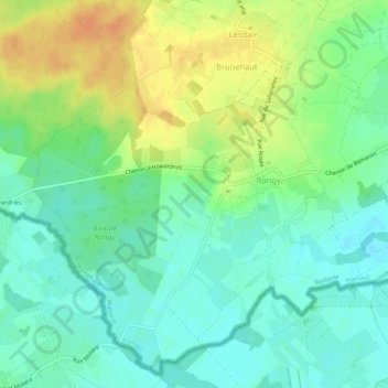
Name: Rongy topographic map, elevation, terrain.
Average elevation: 95 ft
Minimum elevation: 49 ft
Maximum elevation: 167 ft
Make a donation
Gear up for your next adventure:
As an Amazon Associate, this site earns from qualifying purchases at no extra cost to you.
Other topographic maps
Click on a map to view its topography, its elevation and its terrain.
Kluisberg
België > Henegouwen > Doornik-Moeskroen > Mont-de-l'Enclus
De Kluisberg via de zijde Ruien is tevens opgenomen in de recreatieve fietsroute de Vlaanderen Fietsroute, deze route voert tevens over de top op 141 meter hoogte.
Average elevation: 187 ft
Make a donation
Gear up for your next adventure:
As an Amazon Associate, this site earns from qualifying purchases at no extra cost to you.