Geolocate

Manesar topographic map

Click on the map to display elevation.

About this map

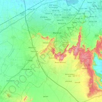
Name: Manesar topographic map, elevation, terrain.

Location: Manesar, Gurugram, Haryana, India (28.23441 76.78249 28.41550 77.01627)

Average elevation: 830 ft

Minimum elevation: 709 ft

Maximum elevation: 1,122 ft

Other topographic maps

Click on a map to view its topography, its elevation and its terrain.

Badshahpur

India > Haryana > Gurgaon

Average elevation: 748 ft

Damdama Lake

India > Haryana > Gurgaon

Average elevation: 794 ft

Gear up for your next adventure:

🎁Geography Themed Gifts - Unique gift ideas for map lovers and geography enthusiasts
📶Vehicle Signal Boosters - Improve reception in rural areas while driving to trailheads
🥾Women's Hiking Boots - Top-rated trail boots with ankle support and superior grip
🔦Compact Flashlight - Reliable flashlight for emergencies
👟Men's Trail Runners - Lightweight footwear for fast-paced exploration and light hiking

As an Amazon Associate, this site earns from qualifying purchases at no extra cost to you.