
Make a donation
Gear up for your next adventure:
As an Amazon Associate, this site earns from qualifying purchases at no extra cost to you.
Xiahe topographic map
Click on the map to display elevation.
Make a donation
Gear up for your next adventure:
As an Amazon Associate, this site earns from qualifying purchases at no extra cost to you.
Xiahe
Xiahe (Sangqu) is found in the southern portion of Gansu province, along the western border with Qinghai province. It lies along the Daxia and Zhao rivers. It is on the northeast edge of the Tibetan Plateau. The average elevation is 2,900 to 3,100 m (9,500 to 10,200 ft) with the highest being 4,636 m (15,210 ft) and the lowest 2,160 m (7,087 ft).
Make a donation
Gear up for your next adventure:
As an Amazon Associate, this site earns from qualifying purchases at no extra cost to you.
About this map
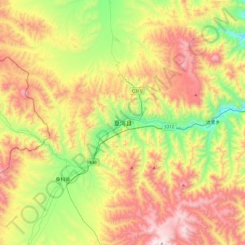
Name: Xiahe topographic map, elevation, terrain.
Average elevation: 11,043 ft
Minimum elevation: 8,871 ft
Maximum elevation: 13,789 ft
Make a donation
Gear up for your next adventure:
As an Amazon Associate, this site earns from qualifying purchases at no extra cost to you.