
Make a donation
Gear up for your next adventure:
As an Amazon Associate, this site earns from qualifying purchases at no extra cost to you.
Ceretolo topographic map
Click on the map to display elevation.
Make a donation
Gear up for your next adventure:
As an Amazon Associate, this site earns from qualifying purchases at no extra cost to you.
About this map
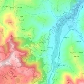
Name: Ceretolo topographic map, elevation, terrain.
Location: Ceretolo, Neviano degli Arduini, Parma, Emilia-Romagna, Italia (44.49720 10.31108 44.53720 10.35108)
Average elevation: 1,417 ft
Minimum elevation: 827 ft
Maximum elevation: 2,382 ft
Make a donation
Gear up for your next adventure:
As an Amazon Associate, this site earns from qualifying purchases at no extra cost to you.
Other topographic maps
Click on a map to view its topography, its elevation and its terrain.
Castello di Bosco di Corniglio
Italia > Emilia-Romagna > Parma > Bosco di Corniglio > La Brea
Average elevation: 2,848 ft
Make a donation
Gear up for your next adventure:
As an Amazon Associate, this site earns from qualifying purchases at no extra cost to you.
Neviano degli Arduini
Italia > Emilia-Romagna > Parma > Neviano degli Arduini
Average elevation: 1,621 ft
Make a donation
Gear up for your next adventure:
As an Amazon Associate, this site earns from qualifying purchases at no extra cost to you.
Make a donation
Gear up for your next adventure:
As an Amazon Associate, this site earns from qualifying purchases at no extra cost to you.
Parco degli Aceri D'argento
Italia > Emilia-Romagna > Parma > Traversetolo > Vignale > Sbizzini
Average elevation: 607 ft