
Thank you for supporting this site ❤️
Make a donation
Make a donation
Gear up for your next adventure:
As an Amazon Associate, this site earns from qualifying purchases at no extra cost to you.
Cazadero topographic map
Click on the map to display elevation.
Thank you for supporting this site ❤️
Make a donation
Make a donation
Gear up for your next adventure:
As an Amazon Associate, this site earns from qualifying purchases at no extra cost to you.
About this map
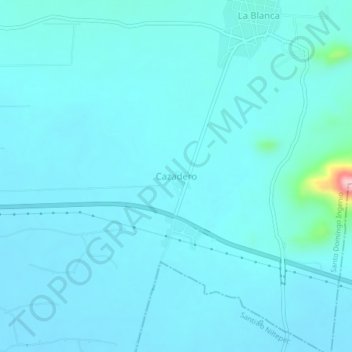
Name: Cazadero topographic map, elevation, terrain.
Location: Cazadero, Santo Domingo Ingenio, Oaxaca, Mexico (16.55562 -94.72173 16.59562 -94.68173)
Average elevation: 171 ft
Minimum elevation: 112 ft
Maximum elevation: 810 ft
Thank you for supporting this site ❤️
Make a donation
Make a donation
Gear up for your next adventure:
As an Amazon Associate, this site earns from qualifying purchases at no extra cost to you.