
Make a donation
Gear up for your next adventure:
As an Amazon Associate, this site earns from qualifying purchases at no extra cost to you.
Brocas topographic map
Click on the map to display elevation.
Make a donation
Gear up for your next adventure:
As an Amazon Associate, this site earns from qualifying purchases at no extra cost to you.
Brocas
Le point le moins élevé se trouve à une altitude d’environ 54 mètres ; il se trouve au sud, à l’endroit où l’Estrigon sort du territoire de la commune. À l’est de la commune, deux points se situent à une altitude d’environ 111 mètres : l'un à quelques mètres de la frontière entre Brocas et Bélis, l’autre un peu plus au sud au niveau du tripoint entre Brocas, Bélis et Maillères.
Make a donation
Gear up for your next adventure:
As an Amazon Associate, this site earns from qualifying purchases at no extra cost to you.
About this map
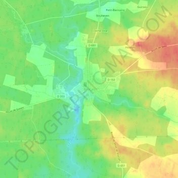
Name: Brocas topographic map, elevation, terrain.
Average elevation: 272 ft
Minimum elevation: 187 ft
Maximum elevation: 358 ft
Make a donation
Gear up for your next adventure:
As an Amazon Associate, this site earns from qualifying purchases at no extra cost to you.