
Make a donation
Gear up for your next adventure:
As an Amazon Associate, this site earns from qualifying purchases at no extra cost to you.
Kenai topographic map
Click on the map to display elevation.
Make a donation
Gear up for your next adventure:
As an Amazon Associate, this site earns from qualifying purchases at no extra cost to you.
About this map
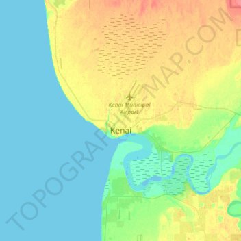
Name: Kenai topographic map, elevation, terrain.
Average elevation: 69 ft
Minimum elevation: -16 ft
Maximum elevation: 253 ft
Kenai Peninsula Borough trails, hiking, mountain biking, running and outdoor activities
Make a donation
Gear up for your next adventure:
As an Amazon Associate, this site earns from qualifying purchases at no extra cost to you.
Other topographic maps
Click on a map to view its topography, its elevation and its terrain.
Make a donation
Gear up for your next adventure:
As an Amazon Associate, this site earns from qualifying purchases at no extra cost to you.
Augustine Volcano
United States > Alaska > Kenai Peninsula Borough
The nearly circular uninhabited island formed by Augustine Volcano is 12 km (7.5 mi) wide east–west, 10 km (6.2 mi) north-south; a nearly symmetrical central summit peaks at altitude 4,134 feet (1,260 m).
Average elevation: 2,159 ft
Make a donation
Gear up for your next adventure:
As an Amazon Associate, this site earns from qualifying purchases at no extra cost to you.
Mount Iliamna
United States > Alaska > Kenai Peninsula Borough
Holocene eruptive activity from Iliamna is little known, but radiocarbon dating seems to indicate at least a few eruptions, all before the European settlement of Alaska. Prehistoric eruptions have been dated to 5050 and 2050 BCE (VEI-4), 450 BCE and 1650. Historically observed eruptions took place in 1867…
Average elevation: 7,743 ft
Augustine Volcano
United States > Alaska > Kenai Peninsula Borough
The nearly circular uninhabited island formed by Augustine Volcano is 12 km (7.5 mi) wide east–west, 10 km (6.2 mi) north-south; a nearly symmetrical central summit peaks at altitude 4,134 feet (1,260 m).
Average elevation: 2,159 ft
Make a donation
Gear up for your next adventure:
As an Amazon Associate, this site earns from qualifying purchases at no extra cost to you.
Make a donation
Gear up for your next adventure:
As an Amazon Associate, this site earns from qualifying purchases at no extra cost to you.
Augustine Volcano
United States > Alaska > Kenai Peninsula Borough
The nearly circular uninhabited island formed by Augustine Volcano is 12 km (7.5 mi) wide east–west, 10 km (6.2 mi) north-south; a nearly symmetrical central summit peaks at altitude 4,134 feet (1,260 m).
Average elevation: 2,159 ft
Mount Iliamna
United States > Alaska > Kenai Peninsula Borough
Holocene eruptive activity from Iliamna is little known, but radiocarbon dating seems to indicate at least a few eruptions, all before the European settlement of Alaska. Prehistoric eruptions have been dated to 5050 and 2050 BCE (VEI-4), 450 BCE and 1650. Historically observed eruptions took place in 1867…
Average elevation: 7,743 ft
Make a donation
Gear up for your next adventure:
As an Amazon Associate, this site earns from qualifying purchases at no extra cost to you.