
Thank you for supporting this site ❤️
Make a donation
Make a donation
Gear up for your next adventure:
As an Amazon Associate, this site earns from qualifying purchases at no extra cost to you.
Walna topographic map
Click on the map to display elevation.
Thank you for supporting this site ❤️
Make a donation
Make a donation
Gear up for your next adventure:
As an Amazon Associate, this site earns from qualifying purchases at no extra cost to you.
About this map
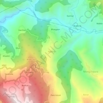
Name: Walna topographic map, elevation, terrain.
Location: Walna, Ranikhet, Almora, Uttarakhand, 263645, India (29.66242 79.40356 29.70242 79.44356)
Average elevation: 4,170 ft
Minimum elevation: 3,156 ft
Maximum elevation: 5,781 ft
Thank you for supporting this site ❤️
Make a donation
Make a donation
Gear up for your next adventure:
As an Amazon Associate, this site earns from qualifying purchases at no extra cost to you.