
Thank you for supporting this site ❤️
Make a donation
Make a donation
Gear up for your next adventure:
As an Amazon Associate, this site earns from qualifying purchases at no extra cost to you.
Weiler-la-Tour topographic map
Click on the map to display elevation.
Thank you for supporting this site ❤️
Make a donation
Make a donation
Gear up for your next adventure:
As an Amazon Associate, this site earns from qualifying purchases at no extra cost to you.
About this map
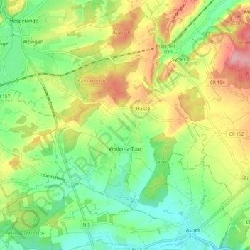
Name: Weiler-la-Tour topographic map, elevation, terrain.
Location: Weiler-la-Tour, Canton Luxembourg, Luxembourg (49.51698 6.15541 49.57778 6.23548)
Average elevation: 932 ft
Minimum elevation: 758 ft
Maximum elevation: 1,178 ft
Thank you for supporting this site ❤️
Make a donation
Make a donation
Gear up for your next adventure:
As an Amazon Associate, this site earns from qualifying purchases at no extra cost to you.