
Make a donation
Gear up for your next adventure:
As an Amazon Associate, this site earns from qualifying purchases at no extra cost to you.
Hassenroth topographic map
Click on the map to display elevation.
Make a donation
Gear up for your next adventure:
As an Amazon Associate, this site earns from qualifying purchases at no extra cost to you.
About this map
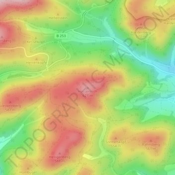
Name: Hassenroth topographic map, elevation, terrain.
Average elevation: 1,608 ft
Minimum elevation: 1,142 ft
Maximum elevation: 2,054 ft
Make a donation
Gear up for your next adventure:
As an Amazon Associate, this site earns from qualifying purchases at no extra cost to you.
Other topographic maps
Click on a map to view its topography, its elevation and its terrain.
Weifenbach
Deutschland > Hessen > Landkreis Marburg-Biedenkopf > Biedenkopf
Die Statistisch-topographisch-historische Beschreibung des Großherzogthums Hessen berichtet 1830 über Weifenbach.
Average elevation: 1,555 ft
Breidenstein
Deutschland > Hessen > Landkreis Marburg-Biedenkopf > Biedenkopf
Average elevation: 1,240 ft