Geolocate

Fort Smith topographic map

Click on the map to display elevation.

About this map

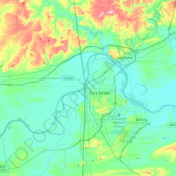
Name: Fort Smith topographic map, elevation, terrain.

Location: Fort Smith, Sebastian County, Arkansas, 72901, United States (35.22722 -94.58490 35.54722 -94.26490)

Average elevation: 535 ft

Minimum elevation: 374 ft

Maximum elevation: 1,109 ft

Sebastian County trails, hiking, mountain biking, running and outdoor activities

Gear up for your next adventure:

Solar GPS Watches - Advanced multisport watches with built-in topographic maps
🪶Thermal Camp Blanket - Extra warmth for cold nights
🥾Women's Hiking Boots - Top-rated trail boots with ankle support and superior grip
👖Convertible Hiking Pants - Versatile zip-off pants for changing altitudes and temperatures
🧷Carabiner Set - Durable clips for gear attachment

As an Amazon Associate, this site earns from qualifying purchases at no extra cost to you.