
Make a donation
Gear up for your next adventure:
As an Amazon Associate, this site earns from qualifying purchases at no extra cost to you.
Langenwiese topographic map
Click on the map to display elevation.
Make a donation
Gear up for your next adventure:
As an Amazon Associate, this site earns from qualifying purchases at no extra cost to you.
Langenwiese
Kleinere Orte und Weiler: Bachorza (Wiesenthal) | Dzikowizna | Grzybowo (Grzybowen/Birkensee) | Hermanowa Wola (Hermanawolla/Hermannshorst) | Ławki (osada) (Gut Lawken/Domäne Lauken) | Knis-Podewsie (Gneisthöhe) | Kronowo (osada) | Mleczkowo (Reichenhof) | Mrówki (Mrowken/Neuforst) | Ryn (kolonia) | Ryński Dwór (Rheinshof) | Ryńskie Pole (Rheinsfelde) | Siejkowo (Justusberg) | Skorupki (Skorupken/Schalensee) | Zielony Lasek (Grünwalde)
Make a donation
Gear up for your next adventure:
As an Amazon Associate, this site earns from qualifying purchases at no extra cost to you.
About this map
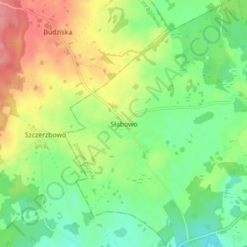
Name: Langenwiese topographic map, elevation, terrain.
Average elevation: 531 ft
Minimum elevation: 423 ft
Maximum elevation: 686 ft
Make a donation
Gear up for your next adventure:
As an Amazon Associate, this site earns from qualifying purchases at no extra cost to you.