Geolocate

Cheyenne topographic map

Click on the map to display elevation.

About this map

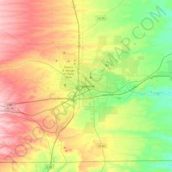
Name: Cheyenne topographic map, elevation, terrain.

Location: Cheyenne, Laramie County, Wyoming, 82002, United States (40.97998 -104.98025 41.29998 -104.66025)

Average elevation: 6,204 ft

Minimum elevation: 5,722 ft

Maximum elevation: 6,860 ft

Laramie County trails, hiking, mountain biking, running and outdoor activities

Other topographic maps

Click on a map to view its topography, its elevation and its terrain.

Ranchettes

United States > Wyoming > Laramie County > Cheyenne

Average elevation: 6,132 ft

Sloans Lake

United States > Wyoming > Laramie County > Cheyenne

Average elevation: 6,138 ft

South Greeley

United States > Wyoming > Laramie County > Cheyenne

Average elevation: 6,060 ft

Gear up for your next adventure:

🪶Paracord Bracelet - Survival bracelet with built‑in tools
🧼Biodegradable Camping Soap - Eco‑friendly soap for outdoor hygiene
🧯Emergency Survival Kit - All‑in‑one survival essentials for the backcountry
📱Solar Portable Charger - Solar power bank for charging devices off‑grid
🔭Compact Binoculars - HD vision for scouting terrain and identifying distant landmarks

As an Amazon Associate, this site earns from qualifying purchases at no extra cost to you.